Sto portanto avanti per hobby un progetto di registrazione di antiche mappe di Piedimonte Matese, la mia città natale, in particolare riferito all’antico Cotonificio ora demolito.
Il compito non é per nulla facile, a causa dei sistemi di riferimento usati nelle mappe e il trovare punti di ancoraggio, edifici o luoghi naturali, esistenti nelle mappe e tutt’ora localizzabili.
Queste mappe mappe un modo per mostrare questo lavoro e avere aiuto.
Sono aperto a qualsiasi informazione,cooperazioni o foto riguardo alla struttura del cotonifio.
Contattatemi a kidpixo [at] gmail.com o cercatemi su qualsiasi piattaforma come kidpixo.
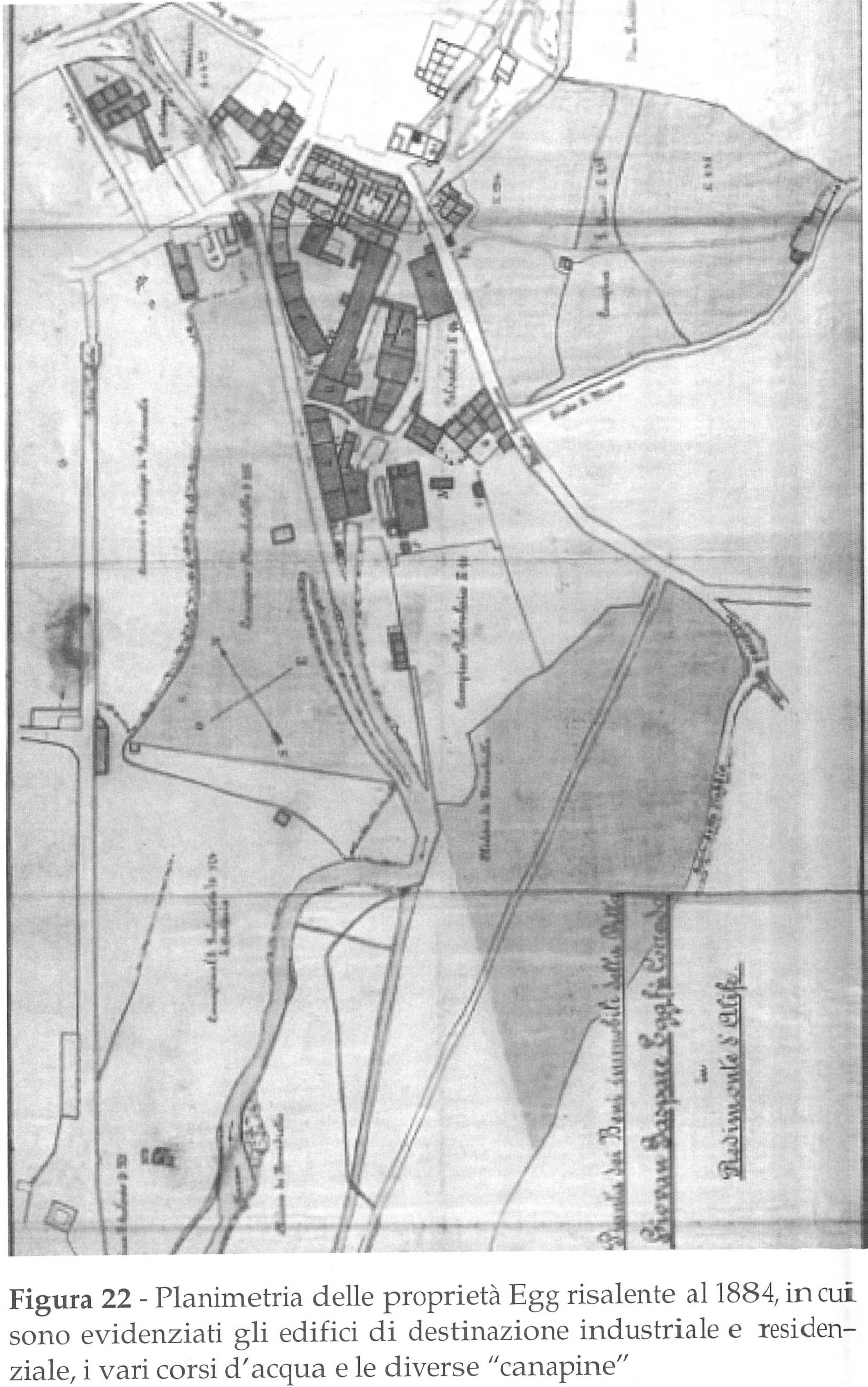
La mappa del 1884 proviene dal libro “Il cotonificio Egg di Piedimonte d’Alife”.1. La versione nella mappa é stata artificialmente ingrandita grazie alla AI, a scapito di perdere le scritte. Versione originale e scalata.
La mappa del 1940 proviene anche dal libro “Il cotonificio Egg di Piedimonte d’Alife”.1.
La mappa del 1964 é stata trovata da Daniela Mastrolorenzo nella Biblioteca comunale di Piedimonte Matese, ringrazio vivamente per le foto.
L’aerofotogrammetria del ~1970 é stata fornita da Vittorio Imperadore, ringrazio vivamente per le foto.
[Top]
I am pursuing as a hobby a project to record ancient maps of Piedimonte Matese, my hometown,, especially related to the old Cotonificio, now demolished.
The task is not easy, due to the reference systems used in the maps and the challenge of finding anchor points, buildings, or natural places that exist in the maps and are still locatable today.
These maps are a way to showcase this work and seek help.
I am open to any information, cooperation, or photos regarding the structure of the cotonificio.
Contact me at kidpixo [at] gmail.com or find me on any platform as kidpixo.
The 1884 map comes from the book “Il cotonificio Egg di Piedimonte d’Alife”.1 The version in the map has been artificially enlarged using AI, at the expense of losing the writings. Original version and upscaled.
The 1940 map also comes from the book “Il cotonificio Egg di Piedimonte d’Alife”.1
The 1964 map was found by Daniela Mastrolorenzo in the municipal library of Piedimonte Matese. Many thanks for the photos.
The aerial photogrammetry of ~1970 was provided by Vittorio Imperadore. Many thanks for the photos.
[Top]
Ich verfolge als Hobby ein Projekt zur Dokumentation alter Karten von Piedimonte Matese, meine Heimatstadt, insbesondere im Zusammenhang mit der inzwischen abgerissenen alten Baumwollspinnerei.
Die Aufgabe ist keineswegs einfach, aufgrund der in den Karten verwendeten Bezugssysteme und der Schwierigkeit, Ankerpunkte, Gebäude oder natürliche Orte zu finden, die in den Karten existieren und heute noch lokalisiert werden können.
Diese Karten sind ein Weg, diese Arbeit zu zeigen und um Hilfe zu bitten.
Ich bin offen für jegliche Informationen, Zusammenarbeit oder Fotos bezüglich der Struktur der Baumwollspinnerei.
Kontaktieren Sie mich unter kidpixo [at] gmail.com oder suchen Sie mich auf jeder Plattform als kidpixo.
Die Karte von 1884 stammt aus dem Buch “Il cotonificio Egg di Piedimonte d’Alife”.1 Die Version in der Karte wurde mithilfe von KI künstlich vergrößert, wodurch die Beschriftungen verloren gingen. Originalversion und hochskaliert.
Die Karte von 1940 stammt ebenfalls aus dem Buch “Il cotonificio Egg di Piedimonte d’Alife”.1
Die Karte von 1964 wurde von Daniela Mastrolorenzo in der Stadtbibliothek von Piedimonte Matese gefunden. Vielen Dank für die Fotos.
Die Luftbildphotogrammetrie von ~1970 wurde von Vittorio Imperadore bereitgestellt. Vielen Dank für die fotos.
[Top]